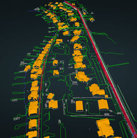
COMPLETE LiDAR & MAPPING SOLUTION
Acquisition, Processing, Advanced Analytics
GOAL
Quality. Time. Cost.
We provide an assortment of
high quality LiDAR deliverables quickly and at a fraction of the price.
QUALITY
Our technology provides centimeter level precision and accuracy, with high levels of detail, complementing your project work.
TIME
Our average turnaround time is between
1 and 2 weeks
COST
Less time means less cost.
It's that simple.

AQUIRE FIELD DATA
Combining GPS & LiDAR Technology

PROCESS DELIVERABLES
Data Processed into standard or custom products

DATA DELIVERY
Data provided into client specific formats or via Stitch3D
03
MULTI-METHOD DATA CAPTURE
TERRESTRIAL, SLAM, And UAV LIDAR ACQUISITION
We have extensive experience pairing the right technology, data capture method, and advanced analytics required to meet your project needs.
Our core business is UAV LiDAR Mapping, but we have since expanded our capabilities into a multitude of data capture methods to meet the needs of our customers.
We are geospatial experts. We make sure the data is captured, processed, converted properly before it is delivered to our clients.
We also can incorporate other data, such as existing land survey control points, or historic geospatial data in order to align all project deliverables.
05
TESTIMONIALS
“Russ was an absolute pleasure to work with. He was responsive and his communication was thorough and detailed at every step of the project. His technical expertise and professionalism is rare to find and I highly recommend him for any project that requires a top-notch level of due diligence. I appreciated him walking us through accessing the deliverables in an easy and secure manner. We also heard great feedback from others in the industry on the quality of his work. We look forward to working with him on future projects."
Anna H / GIS Manager / Hawthorne Renewables
“The Lidar services save me at 4 days of very expensive survey work due to the rough terrain. The accuracy was incredible where we were able to take proof shots."
Jay B / Surveyor
“DOUBLE CLICK HERE OR CLICK EDIT TEXT TO ADD SOME POSITIVE FEEDBACK ABOUT YOUR SERVICES"
NAME / JOB / TITLE


